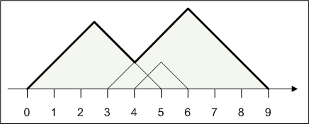
Your friend is going to the mountains on vacation. He will climb up and down several mountains, and he has asked you to calculate his total walking distance.
To simplify this task, everything will be represented on a 2-dimensional cartesian plane. The ground is represented as the x-axis, and the mountains are represented as the union of several isosceles triangles. You are given int[]s start and finish. For each index i, construct an isosceles right triangle with its hypotenuse lying on the ground from point start[i] to point finish[i].

The mountains are guaranteed to form a single connected non-degenerate polygon, where the height is positive everywhere between the start and end points. The path your friend will walk is defined as the upper part of this mountain, shown in bold in the figure above. Return the length of this path.
| 